
 Medialab-Matadero Madrid
Workshop Showcase · Second Inclusiva-net Meeting: Digital Networks and Physical Space
Desde 26/03/2008 12:03 hasta 18/05/2008 12:05
During the two weeks of the production workshop Inclusiva-net: Digital Networks and Physical Space, these ten projects have been collaboratevely developed. The prototypes will be on display at Medialab-Prado until May 28th.
The workshop was lead by Julian Oliver and Lalya Gaye, with the participation Juan Antonio Fabián and Steven Pickles.
Projects
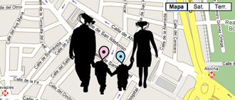
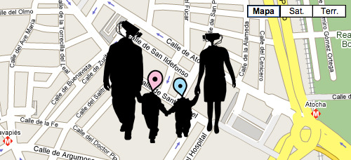
Una Ciudad Mejor (1CM) / A Better City
By Flavio Escribano & Ana G. Angulo
Collaborators: Horacio Gónzalez (escoitar.org), Mónica Rojas, Fernando Krum y Coco Moya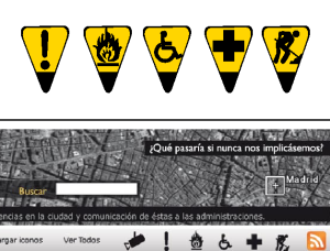
Una ciudad mejor (A Better City) is an online application, based on social network (or Web 2.0) methods, protocols, standards, and services (Google Maps’ API), to stimulate democratic participation in the configuration of cities, by making it possible for citizens to communicate incidents, inconveniences, and urban problems of all kinds that arise in their daily lives.
Security vs. Liberty: Hobbes vs. Locke, the debate continues...
By Miguel Angel Lastra Cobo
Collaborators: Mario Gutiérrez Cruz, Lorena Briscoe, Frederique Muscinesi, Laura López Ruiz, Olga Manzanaro, Inhye Lee, Javier Ruiz, Fco José Hinojosa, Ángel Galán, Aniara Rodado, José Plana, Coco Moya.
This project will map out the security cameras installed on the streets of Madrid, and then suggest a game: Can you get from one part of the city to another, without being recorded on any of the cameras?
http://www.inclusiva-net.es/seguridadvslibertad/
More info:
http://cameramap.addsensor.com
http://www.addsensor.com/medialab/
http://addsensor.brokenloop.org/links/
Local Feed
By Domenico Di Siena
Collaborators: Horacio Gónzalez (escoitar.org)
Collaborative feeds that can be edited, with hyper-local, geo-referenced information.
Local Feed aims to associate maps (geo-referencing), feeds (syndication), and wiki technology (collaboration) in order to create a Web portal where all kinds of local information and local social networks can be visualized.Using Google Maps' API, this platform will allow its users to collaboratively edit feeds associated with an address or a specific area of the city, taking different scales into account. The intent is to experience new ways of using syndication, by geo-referencing information sources. Thanks to content syndication tools, information from external Web pages of diverse formats can be gathered in one place (map), making the huge amount of information that circulates on the Web more accessible and useful.
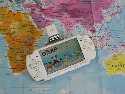
Oterp
By Antonin Fourneau
Collaborators: Alejandro Palmero. Música: Jankenpopp, Saitone, TM.
Make music with a disc of 510 067 420 km² = the Earth or how to use the surface of the earth to realise something between a music game or a real time sound editor.
Oterp is a prototype sound editor within a video game, in which GPS sensors allow you to manipulate music in real-time, based on your location on Earth. As well as generating new sounds, you will also discover and collect different kinds of sounds as you travel. Oterp’s goal is to mix the reality of our environment into game music. It is a way of re-imagining our
daily displacements in a society increasingly on the move.http://www.inclusiva-net.es/oterp/
More info:
http://www.oterp.com/
http://atonews.blogspot.com/2008/01/video-of-daf.html
The Mobility of a Landmark (working title)
By Sandra Nakamura
Collaborators: Luis Ayuso, Juan Fabián, Coco Moya, Mónica Sánchez.
To attempt at finding the center of a city is also to question our own position within it. The center, it has to be assumed, is a mobile indicator rather than a fixed location, whose constant displacement is subjected to our own conception of the city and our activity in it. Inasmuch as the city is an active entity in a process of constant flow and transformation, its center is an active center and should be thought of as a moving, yet invisible landmark.
The objective of this project is to develop a strategy to calculate the center of a given city. It aims to challenge our very own perception of the city and its boundaries, reflecting on how that personal image has been shaped, not only by our preferences and daily routines, but through those very same places as they have been imagined, experienced, documented, and shared by others.
Thinking of map-making as an increasingly collective and interactive endeavor, the project intends to redefine the limits of the city we have set up for ourselves through the simple yet seemingly impossible task of pinpointing the exact center of the city.
http://www.inclusiva-net.es/centrociudad/
In Hear, Out there
By Matt Green
Collaborators: Andrew Henley, María Prieto, Artur Vidal, Luis Ayuso y Carlos Panero Zurbriggen
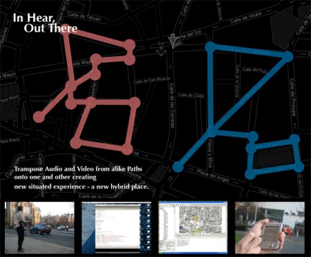
Conceive a catalogue, a map of sound/video from place – from everyday environments – from out in the street. Account how this map could be edited and updated by a network community.
Conceive a manner by which an environment, a path, a locale from another place can be aurally/visually transposed, fitted, juxtaposed to your place – putting you within a hybrid place – is your attention in or out, in and out?
Using GPS and a sound/video recording equipment two differing walks through (or outside of) Madrid will be documented and a map will be created.
Similarities in path shapes will be noted. Similarities or fitting contrasts in sound/video content will be noted. Hence, two new mappings will be created - the sense of walk 1 is transposed onto walk 2 and visa-versa. Hence, Madrid can become Sydney – or a fusion – Madney? Or London – Maddon?
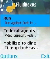
Fluid Nexus
By Nick Knouf
Collaborators: Bruno Vianna, Luis Ayuso.
Fluid Nexus is an application for mobile phones that is primarily designed to enable activists to send messages and data amongst themselves independent of a centralized cellular network. The idea is to provide a means of communication between people when the centralized network has been shut down, either by the government during a time of unrest, or by nature due to a massive disaster. During such times the use of the centralized network for voice or SMS is not possible. Yet, if we can use the fact that people still must move about the world, then we can use ideas from sneaker-nets to turn people into carriers of data. Given enough people, we can create fluid, temporary, ad-hoc networks that pass messages one person at a time, spreading out as a contagion and eventually reaching members of the group. This enables surreptitious communication via daily activity and relies on a fluid view of reality. Additionally, Fluid Nexus can be used as a hyperlocal message board, loosely attached to physical locations.
http://www.inclusiva-net.es/fluidnexus/
More info:
http://zeitkunst.org/blog/2008/01/20/paper-accepted-for-isea/
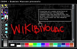
Wikibivouac
By ZOOM + Damien Masson
Collaborators: Damien Masson, Chameleon Diego Cerda, Cristina Brasci y Antoine Petitjean
ZOOM would like to experiment how a wiki-like cartographic system can generate new territory practices and new representations of urban spaces.
The creation of a «collaborative map» gathering the urban environment «parallel» informations. On the one hand, these information concern what could support a nomadic occupancy of the territory, such as hitchhiking areas, material and food retrieval places, water spots, empty places ready for occupancy. On the other hand, these maps can also contains information such as the surveillance areas, places were traffic is forbidden, etc.
The proposed project is linked with the questions and experimentations that have been put forward by ZOOM about the link between Internet and the physical territory :http://www.inclusiva-net.es/wikibivouac/
More info:
www.wikibivouac.orghttp://www.zoomarchitecture.fr/wikibivouac/
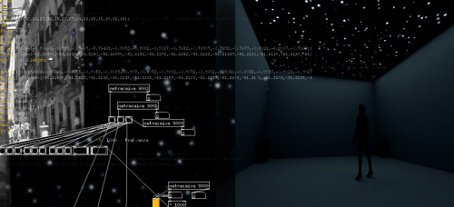
Earth on Heaven
By Marie Polakova & Ofer Smilansky
Collaborators: Krystof Pesek, Bruno Vianna, Jeff Knowlton.
If our steps transform into a trail of stardust, our world on Earth into galaxies and the sound we perceive folds itself into new forms… what remains then?
The ‘Earth On Heaven’ project uses the data from the physical space to form a digital environment which reflects the individual’s “universe” on Earth.The input data is:
-geographic coordinates of locations which the individual considers personally important
-GPS track logs
-field sound recordings of subjectively chosen sounds from the environmentThe geographic coordinates are converted into an image of a starry sky, using a traditional cartographic projection method. The position of the stationary stars depends on the geographic coordinates of the places they represent. Their size represents the importance that those places hold for the person who created the “map”. The GPS tracks use the same cartographic method and are transformed into paths along which a “moving light” object trails. Sounds, a combination of manipulated samples and natural ambient recordings, are edited and placed in the locations in the ‘Earth on Heaven’ sky. Once the moving light comes closer to a stationary star the sound in that location is triggered and heard.
The output is a moving image projected onto the ceiling of the installation space and quadraphonic sound.
http://www.inclusiva-net.es/earthonheaven/
Maxi-Redes Cube Stomper
By Anne-Marie Schleiner & Luzia Ornelas
The Maxi-Redes Cube Stomper is a collection of strategic and economical designs using prefab easily obtained components and web software in innovative combinations, following the DIY modular approach exhibited on informational websites such as Hack-a-day (http://www.hackaday.com/) or IKEA hackers. While resolving many serious dilemmas of the net art vs. gallery conundrum, Maxi-Redes Cube Stomper implements the playful spirit of net art in physical and spatial ways, bridging the web, the gallery and the street, and simultaneously flattening techo-elitism and the white cube.
Some examples of these desegns are the Web Cam Vacu-bot, Medium Translation Kits opr Wireless Headphone Audio Tour.
Place:
Medialab-Prado. Plaza de las Letras, C/ Alameda, 15 · Madrid
Sessions of the activity
The activity is over
Programa:
Inclusiva-net